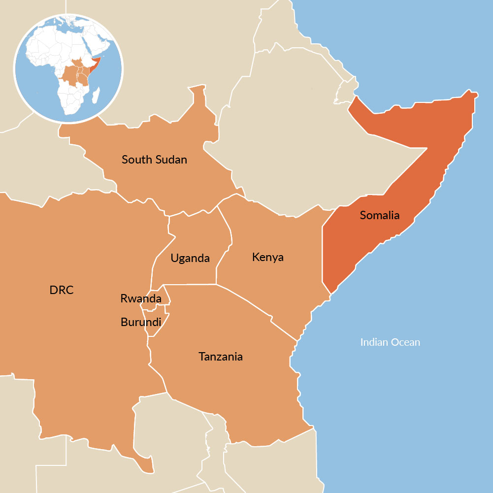
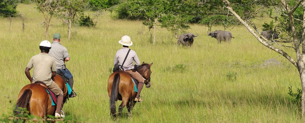
 East Africa is endowed with a unique combination of tourist attractions, comprising tropical beaches, abundant wildlife in natural habitats, scenic beauty and a geographically diverse landscape that spark imagination, reward the senses, stimulate the intellect and enliven the spirit. The region is home to some of the biggest populations of charismatic mammals including the elephant, rhinoceros, lion, chimpanzee and mountain gorilla. For those who love fun and adventure, East Africa is not short of opportunities, in the contrary, the region has unusual, exotic, remote and wilderness attractions that meet the expectations and tastes of varied enthusiasts of fun and adventure. One can enjoy adventure ranging from wildlife safaris, bird watching, windsurfing, horseback riding, golfing, canoeing, Kayaking, mountain biking, snorkeling, scuba diving, hot air ballooning, mountain climbing, gorilla trekking, heritage and cultural tours, white water rafting, deep sea diving and fishing, bungee jumping, paragliding and sky diving just to mention a few. For one to really experience the wonders of East Africa, a multi – destination tour combining two or more countries of the East African Community is highly recommended. It is quite rewarding to scale the heights of the tallest mountain in Africa, that is Mount Kilimanjaro in Tanzania and within the same trip savor the spectacle of wildebeest migration between Serengeti in Tanzania and Maasai Mara in Kenya. One may also choose to combine gorilla trekking in the Bwindi Impenetrable National Park in Uganda or even from Virunga National Park in DRC with a stay in one of the exotic beach hotels along the East African Coast.
- Background information; by edgardowelelo@yahoo.com
- Juba, the capital city in South Sudan, is on the White Nile, and the total area of South Sudan at large is approximately 620,000 Sq.km. Annual rain, falling mainly from April through November, reaches 40” (1,000 mm). Average highs are 100°F (38°C) in February and 88°F (31°C) in July. In Nimule National Park (101,300 acres/41,000 ha), south of Juba on the banks of the Nile at the Uganda border, smaller rivers run off the Ilingua Mountains through wooded savanna. The white rhino was the centerpiece here, along with the elephant, Kob, hippo, buffalo, and Nile lechwe. Bandingilo National Park (4,075,500 acres/1,650,000 ha) and Shambe National Park (153,100 acres/62,000 ha) flank the Nile north of Juba. Both are home to Nile lechwes, giraffes, and elephants. The Sudd marshes (known as the Sudd) are vast, seasonally flooded wetlands along the Nile north of the two parks that even out the flood pulse of the great river. Varying water levels influence the movements of vast herds of mammals, including elephants, topis (Tiang race), and lots of individuals of the mongalla race of Thomson’s gazelle, reedbucks, Nile lechwes and Sitatungas.
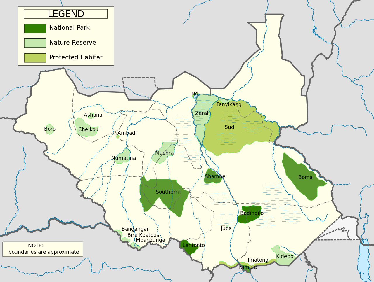
- The waters and skies are full of waterbirds and raptors year – round. The Sudd is the main home of the shoebill, the black crowned crane, and wintering Eurasian birds, including the ruff. Zeraf Game Reserve (2,395,900 acres/970,000 ha) protects a large portion of the Sudd marshes east of the Nile. The massive Jonglei Canal project will channel much of the Nile’s water away from the Sudd, its cattle – raising Dinka people, and the wildlife. The goal of this ambitious project is to tame the Nile, opening up the Sudd for agriculture and providing more water for irrigation downstream. Southern National Park (5,681,000 acres/2,300,000 ha) is a vast savanna park in the west, south of Wau. It has not been developed, but in the past the area has been home to the giant eland, giraffe, buffalo, lion, roan, wild dog, and white rhino. Bangangai Game Reserve (42,000 acres/17,000 ha) has dense tropical evergreen forest on the Democratic Republic of Congo (DRC) border, 50 mi (80 km) west – northwest of Yambio. It is home to nine primates, including the chimpanzee, four duikers, three pigs, the bongo, the forest elephant, and both Cape and forest races of buffalo. Bird life includes the long tailed hawk, great blue turaco, and black – bellied seed cracker. East of Juba, the Imatong Mountains rise to 10,456” (3,187 m), with unprotected cool wet forests and many plants and animals found nowhere else in South Sudan. Boma National Park (5,631,600 acres/2,280,000 ha), located on the Ethiopian border 180 mi (300 km) northeast of Juba, at a juncture of ecosystems at 1,300 – 3600” (400 – 1,100 m), has the richest diversity of fauna in South Sudan and perhaps in Africa. It has montane forest on the Boma Plateau, arid Somali semi – desert, wooded savanna, and vast swamps. Like the Serengeti, it is home to seasonal migrations of hundreds of thousands of mammals. The herds spend January through April in the dry floodplains in the northeast, leaving the park for better – drained areas to the southwest in the wet season. These herds involve thousands of white – eared kob, plus topis (tiang race), elands, plains zebras, hartebeests, reedbucks, and Thomson’s gazelles (Mongalla race). Elephants, hippos, beisa oryxes, lesser kudus, dik – diks, Grant’s gazelles, Cheetahs, and shoebills also live in the park.
- Background information: by edgardowelelo@yahoo.com.
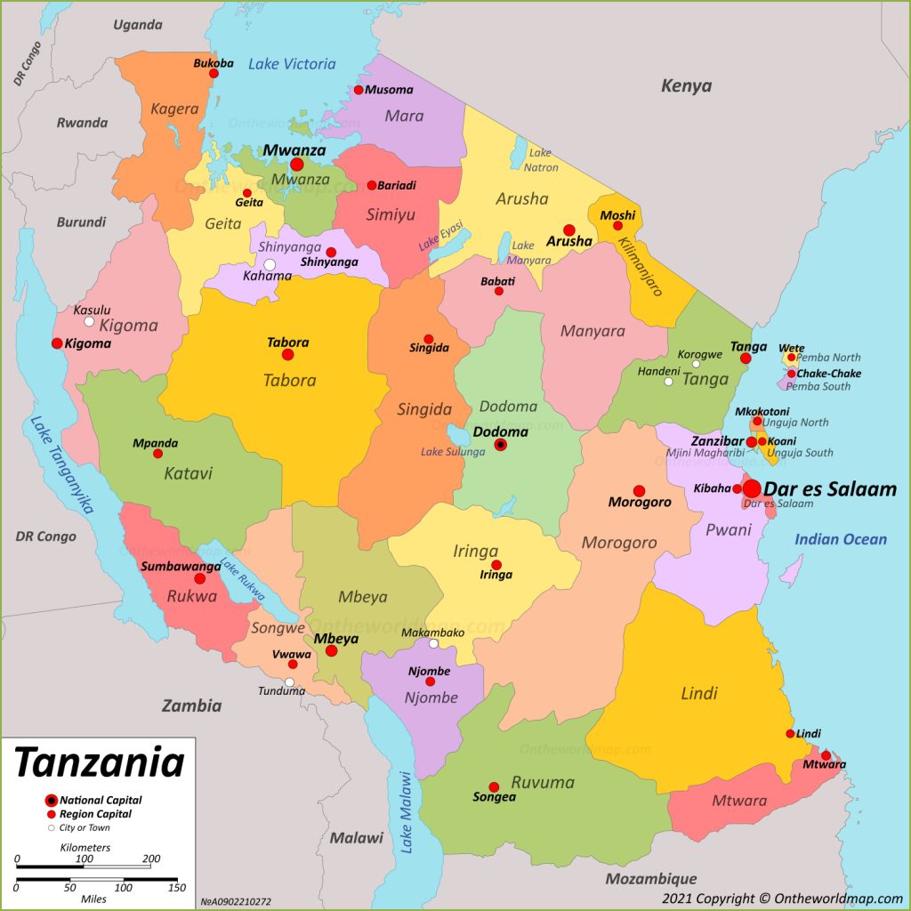
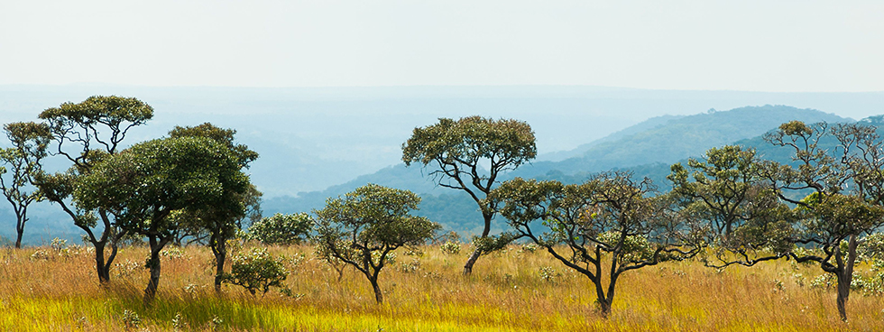
The Second – largest country in East Africa after the Democratic Republic of Congo (DRC) with an area of 947,300 Sq. km. Tanzania lies just south of the equator, between the Indian Ocean and the great lakes of Victoria (Nyanza), Tanganyika, and Malawi (Nyasa). Westward from its narrow coastal plain the land rises steadily to the 3,000 – 5000” (900 – 1,500 m) plateau that comprises most of the country. The landscape is dramatically interrupted by the eastern and western rift valleys and fertile highlands punctuated with extinct volcanoes. The north of the country is a mix of acacia savanna and open grassland, while the central and southern regions of the country are chiefly miombo woodland (Zambezian region). The cool highlands have montane forests; wet tropical forest patches occur in the northwest, and stunted coastal forests in the east. The north of the country (Northern zone) has two rainy seasons: the long rains between March and June, and the short rains from mid – October through December. The South of the country and other parts countrywide has a single rainy season between November and April. More than one – quarter of the country is under some form of protection. Tanzania is the home of the world – famous Serengeti and Ngorongoro safari circuit.
- THE ARUSHA REGION (NORTHERN TANZANIA)
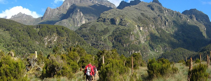
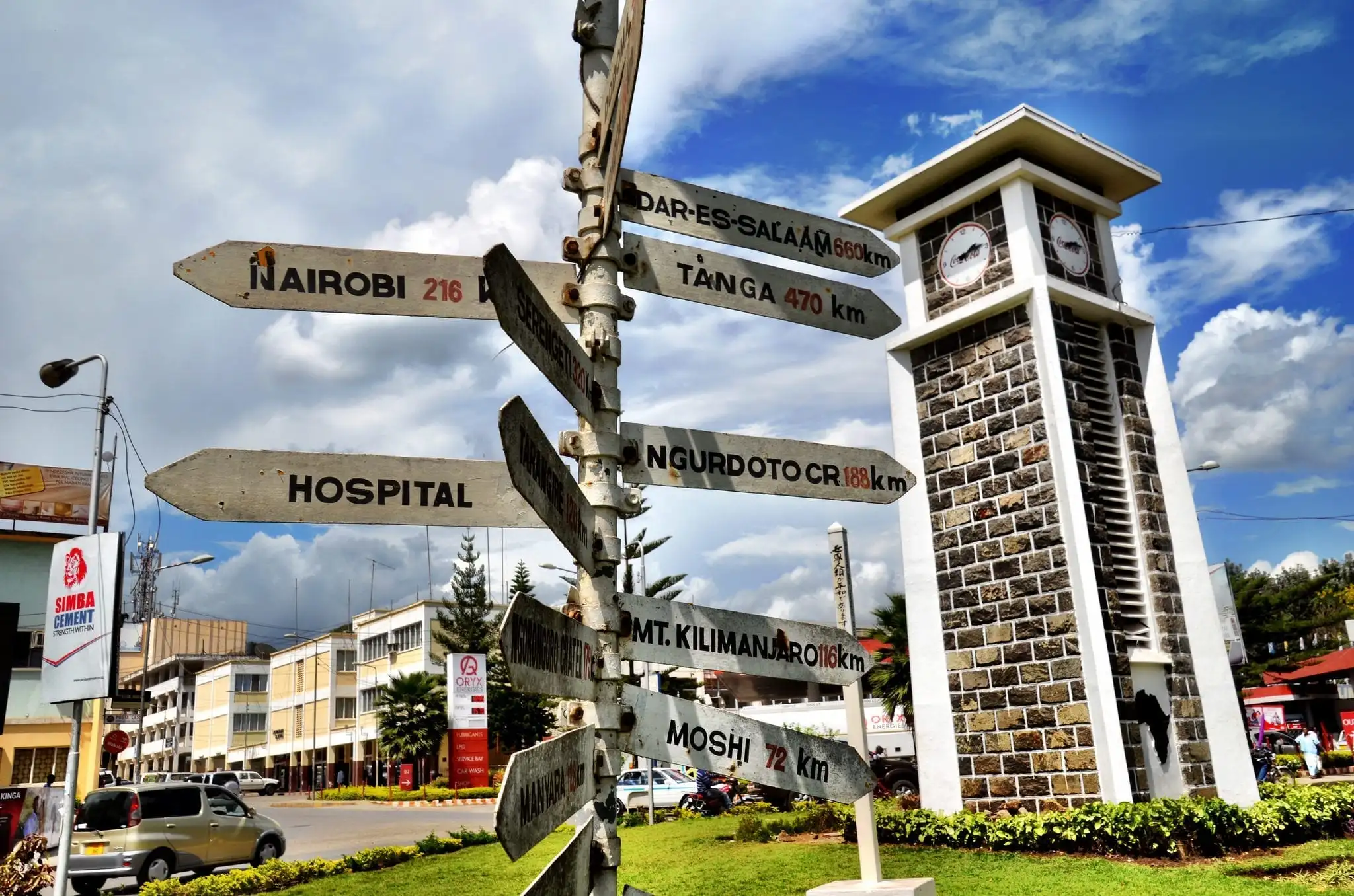 Arusha Region, the main city and safari center of the north, is connected to Nairobi, Kenya, by paved road; it is an hour west of Kilimanjaro International Airport (KIA). Visitors can choose from a number of hotels in town and lodges set among verdant plantations in the eastern outskirts. Arusha National Park (ANAPA,552 Sq. km) and Mount Meru Game Reserve (74,100 acres/30, 000 ha) which is currently part of Arusha National Park, flank 14,979” (4,566 m) Mount Meru, which rises north of Arusha. There is a lodge on the eastern slope of Mount Meru near the Mommela Lakes, which are surrounded by brushland with giraffes, bushbucks, and waterbucks. Visitors accompanied by an armed ranger – guide may walk along the lakes, which host flamingos, Cape teals, maccoa ducks, and waders. The forested rim of mile – wide Ngurdoto Crater (Caldera) overlooks a swampy crater floor well – trod by elephants, buffalos, and other mammals. The crater rim is home to silvery – cheeked hornbills, black – and – white colobus monkeys, and Harvey red duikers. The mountain’s annual rainfall of up to 96” (2,400 mm) nourishes dense montane forest, which yields to moorland higher up. Those wishing to climb all or part of Mount Meru can hire safari guides and stay in modest huts overnight. Crowned eagles, bar – tailed trogons, and montane white – eyes may be spotted from the slopes. Kilimanjaro National Park/World Heritage Site (1668 Sq.km) protects the upper reaches (above 8,860’/2, 700 m) of Africa’s tallest mountain (19,340”/5,895 m), an enormous, freestanding massif, with snowfields and small glaciers among its three volcanoes (Shira, Kibo(Uhuru), and Mawenzi). The park’s lower slopes are cloaked in montane forest hosting Abbott’s duikers and Hartlaub’s turacos. Above this zone, moorland features giant lobelia plants, the four – striped grass mouse, the lammergeyer, and the scarlet – tufted malachite sunbird. Organized five – to seven – day hikes (with nights in huts or tents) traverse cold alpine desert above 13,100” (4,000m), where annual rainfall is only 8” (200m).
- THE EASTERN RIFT VALLEY (EASTERN OR GREGORY RIFT)/EASTERN BRANCH
West of Arusha Region, the eastern side of the rift valley drops down gradually in a series of terraces, while the western wall is impressively steep. Lake Natron, a vast soda lake near the Kenya border, is a major nesting site for flamingos, while the very arid acacia savanna nearby hosts the fringe – eared Oryx. Towering above the southern end of Lake Natron is the perfect volcanic cone of OL Doinyo Lengai, which frequently shows a plume of smoke. Lake Manyara National Park/ Biosphere Reserve (648. 7 Sq.km, land surface 386 Sq. km, and 262. 7 Sq. km Lake Manyara), a slim sanctuary extending from the northern and western parts of Lake Manyara to the top of the western rift valley wall, is (130 km) southwest of Arusha city, just south of the main road to the Serengeti plains. Verreaux’s eagles, vultures, storks, swifts, and swallows wing by lodgings atop the spectacular cliffs overlooking the lake. Springs in the park’s northern end support a dense groundwater forest of giant figs and mahogany, which shelters blue monkeys, baboons, bushbucks, common waterbucks, elephants, and silvery – cheeked hornbills. South of the groundwater forest, acacia woodland and open grassland are frequented by buffalos, wildebeests’ races of Eastern white – bearded wildebeest, Impala, giraffes, zebras, lions, and gray – backed fiscal – Shrikes. Streams attract pythons, Nile monitor lizards, and mountain wagtails. Lake Manyara, at 3,150” (960 m), varies in salinity levels with wetter and drier climate cycles. At times it is replete with flamingos, pelicans, storks, and cormorants. The hippo pool, where visitors may get and of their vehicles, is located on a freshwater stream that enters the lake at its northern tip. Tarangire National Park (2,850 Sq.km) lies near the end of a paved road (120 km) southwest of Arusha city and southeast of Lake Manyara. Its tented lodge and several campsites are set in pretty rolling hills dotted with enormous baobab trees and umbrella acacias. Tarangire hosts many animals, year – round, including elephant herds. During the June to October dry season these are joined by huge herds of zebras and wildebeests from the Maasai steppe, to the east, attracted to the Tarangire River’s permanent water. Resident species include fringe – eared oryxes, impalas, hartebeests, giraffes, steenboks, lions, and leopards. More than 550 bird species have been recorded; among them, yellow – necked and red – necked spur fowls, orange – bellied parrots, yellow – collared lovebirds, bare – faced and white – bellied go – away – birds, magpie shrikes, and ashy starlings.
- NGORONGORO CRATER (COLLAPSED VOLCANO (EXTINCT VOLCANO) IN NORTHERN TANZANIA (ARUSHA REGION)
 On the main road to Ngorongoro Crater, just north of Karatu, Gibb’s Farm – Lodge runs an excellent bird – feeding operation that attracts Reichenow’s weavers, Cape robin – chats, and tropical boubous. Ngorongoro Conservation Area Authority (NCAA)/World Heritage Site and Biosphere Reserve (8,300 Sq. km) protects wildlife habitat as well as the rights of local Maasai who graze their livestock on about 75 percent of the area. Ngorongoro Crater (Collapsed volcano/Caldera), 12 mi (19 km) wide, is the world’s largest intact caldera. Before the cataclysmic collapse of its cone 2 million years ago, this volcanic mountain may have been taller than Kilimanjaro. Its rim, which averages 7,600’ (2,316 m) elevation, is cloaked in moist montane forest and grassland, hosting elephants, golden - winged and eastern double - collared sunbirds, stonechats, and Jackson’s widow birds. From lodges and campsites on the rim, visitors are driven down to the crater floor for a day – long survey. At 5,600” (1,700m) elevation, the crater floor is primarily grassland, with patches of spring – fed marshes, freshwater ponds, a salt lake, and small forests. Harboring thousands of large animals, it is a virtual Noah’s Ark (without giraffes). Great effort has gone into saving the black rhino here, and several dozen are resident. Buffalos, wildebeests, zebras, gazelles, and hartebeests graze the grassland, while elephants roam the wooded areas, and hippos gather in marshes and ponds. Lions, spotted hyenas, and golden and black – backed Jackals are easy to find, and servals and cheetahs are sighted rarely. Resident Ostriches, crowned cranes, and Kori bustards are joined seasonally by migrant flocks of white and Abdim’s storks. Ngorongoro Conservation Area Authority (NCAA) also includes two other voluminous craters, six peaks that top 10,000” (3,000 m), and the southeastern corner of the vast Serengeti Plains. Oldupai Gorge, just north of the road to the Serengeti, has yielded hominid fossils key to the study of human evolution. Here sit a museum and shaded picnic sites. Red – and – yellow barbets join less colorful birds here for crumbs, while cheetahs sometimes roam nearby.
- THE SERENGETI PLAINS (MARA REGION)
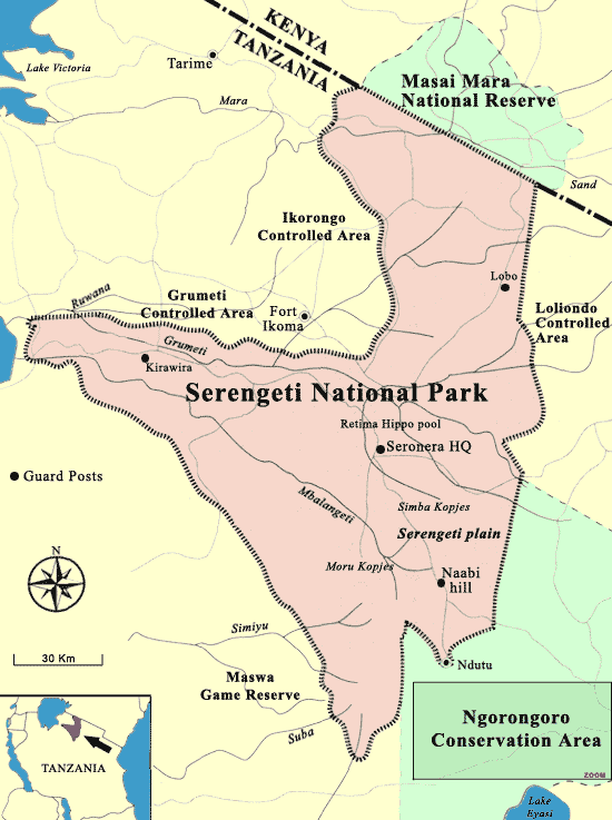 Serengeti National Park/World Heritage Site and Biosphere Reserve (14,763 Sq. km/5700 Sq. miles) lies between Ngorongoro Conservation Area Authority (NCAA) and Lake Victoria (Nyanza) and adjoins Kenya’s Maasai Mara. Currently, Serengeti National Park is Tanzania’s third largest park after J. K. Nyerere National Park (formerly Selous Game Reserve) and Ruaha National Park in Iringa Region. Isolated lodges dot its northern, southern, and western sectors, but the tourism center of the park is Seronera, with several lodges and camps, (335 km) west of Arusha city. To the east and south vast open grasslands are punctuated with occasional Kopjes (rocky outcrops), while to the west and north grasslands are interspersed with hills and open woodland and sliced by rivers. Near Seronera, yellow fever trees (Yellow – barked acacias) and palm thickets line the Seronera River and its hippo pools. This is a superb area for seeing predators such as lions, leopards, and cheetahs, along with giraffes, topis, bohor reedbucks, defassa waterbucks, buffalos, and impalas. The Kopjes host hyraxes, dwarf mongooses, and red – headed agamas. The open grassland to the east is home to large groups of Thomson’s and Grant’s gazelles, spotted hyenas, Jackals, and such birds as the double – banded courser, yellow – throated sandgrouse, red – capped lark, Fischer’s sparrow – lark, and capped wheatear. As part of their famous clockwise migration, more than 2 million wildebeests, accompanied by hundreds of thousands of other herbivores, descend upon the short – grass plains of the southeastern Serengeti at the start of the rainy season around December. After calving in January and February, they scatter over the southern and central plains. By May the rains end, the grass has been reduced to stubble, and the animals begin their long march to dry - season grazing grounds near the permanent waters of the Serengeti’s northern woodlands and Kenya’s Maasai Mara. Reaching these destinations by July or so, they remain until October, when they head back to the Southeastern Serengeti. The seasonally saline Ndutu Lake, in southeastern Serengeti, sits in arid thorny acacia country with a lodge nearby. The area’s inhabitants include Kirk’s dik – diks, giraffes, elephants, lions, pygmy falcons, gray – breasted spurfowls, Fischer’s lovebirds, and rufous – tailed weavers.
- WESTERN TANZANIA
 Lake Victoria (Nyanza), in northwestern Tanzania, is a huge freshwater lake shared with Uganda and Kenya. Rubondo Island National Park (457 Sq. km of which 237 sq. km is dryland and 220 Sq. km is water), on an island in the southwestern corner of the Lake, is home to native sitatungas and hippos and introduced chimps, black rhinos, elephants, and roans. Lake Tanganyika, in the western rift valley opposite the Democratic Republic of Congo (DRC), is the longest lake in Africa. It is very deep, with its floor 1,000”(305 m) below sea level, and hosts an extremely rich fish life. Kigoma, on Lake Tanganyika, is the chief town and port in the west. It receives 37” (925 mm) of rain, and has average highs of 79 - 84°F (26 - 29°C). Gombe Stream National Park (56 Sq. km) is also on the Eastern shore of Lake Tanganyika about 24 kms north of Kigoma. Travel to the park is by water only. Accessible only by boat, it has huts for tourists and a research station. A long – term study of chimpanzees here has habituated them to humans; visitors (with safari guides) may see them at close range. There are trails in tropical evergreen forest in the valleys where baboons, monkeys, and such west African birds as the blue – breasted kingfisher and double – toothed barbet can be seen. Mahale Mountains National Park (1,613 Sq. km/622 Sq. miles) on the eastern shore of Lake Tanganyika is about 150 km South of Kigoma, is a chimpanzee research site, with an airstrip and a seasonal luxury camp. The mountains exceed 8,000” (2,400m), draining 75” (1,875 mm) of yearly rain onto evergreen and montane forest. The wet western slopes are home to chimpanzees, while the miombo woodland of the drier eastern side is inhabited by giraffes, elephants, roans, and lions. Katavi National Park in Katavi Region (4,471 Sq.km), 25 mi (40 km) south of Mpanda, is a floodplain with typically southern mammals such as the Puku, Common reedbuck, sable, and tsessebe, and more than 400 species of birds, including the gray go – away – bird, red – faced mouse bird, and white – winged babbling – starling.
- SOUTHERN TANZANIA
 The less - visited southern parks are best seen in the dry season (May through October), when the dirt tracks are passable. Mikumi National Park in Morogoro Region (3,230 Sq. km), located (295 km) west of the coastal city of Dar es – Salaam on the main highway to Zambia, has lodging and offers wildlife – viewing drives centered on the floodplain of the Mkata River. This scenic area of grassland, enormous baobabs, - miombo woodland, palm thickets, and gallery forests is flanked by mountain ranges. Elephants, giraffes, buffalos, Lichtenstein’s hartebeests, sables, wildebeests, zebras, Impalas, lions, leopards, and wild dogs roam the park. Among 370 bird species are the pale - billed hornbill, the racquet – tailed roller, and Dickinson’s Kestrel. The Uluguru Mountains, just east of Mikumi, is another area of interesting to visit. On these sharp – toothed peaks, which reach 8,200” (2,500m), the montane forests are home to two endemic bird species: a bush - shrike and a sunbird. The vast Selous Game Reserve/World Heritage Site (currently 30,000 Sq. km of its total area of about 55,000 Sq.km has been upgraded to J. K. Nyerere National Park, is one of the Africa’s largest- wildlife sanctuary. It lies south of Mikumi and has airstrips and tracks connecting the lodges and camps. Lions and elephants live throughout Selous. Large numbers of zebras, Impalas, and buffalos inhabit the savannas, while sables, greater Kudus, and Sharpe’s grysboks browse the miombo woodlands. In the northeast the Great Ruaha and Rufiji rivers create a vast inland delta, a maze of seasonal channels flanked by grassy plains, dunes, steep banks, and borassus palm forests. Hippos, crocodiles, and carmine bee – eaters are common. Hunting, encouraged in most of the Selous, is illegal in this sector. Ruaha National Park in Iringa Region, currently, Tanzania’s second largest National Park after J. K. Nyerere National Park with an area of 20,380 Sq. km) sits (120 km) west of the town of Iringa in southwestern Tanzania. An escarpment bisects this refuge, making a near ecological divide between the Ruaha River Valley and the high plateau covered with miombo woodland. The valley sector features spectacular gorges along the Ruaha River, baobabs and euphorbias, flooded grassland, acacia woodland, gallery forests, and graceful isolated hills. Thousands of elephants and many buffalos inhabit the park, along with all the major cats. The superb array of antelopes includes lesser and greater Kudus, Lichtenstein’s hartebeests, sables, roans, elands, steenboks, and oribis. Among the 370 bird species in the area are the purple – crested turaco, Pel’s fishing owl, and the ashy starling. Udzungwa Mountains National Park (located and found in both Iringa Region (80%) and Morogoro Region (20%), south of the Iringa, hosts the Sanje mangabey and montane forest birds with restricted ranges. This national park covers an area of 1990 Sq. km, and it was established in 1992.
 Dar- es – Salaam, the commercial capital, gets 42” (1,050 mm) of annual rain, chiefly between November and May. It is humid, and has average highs of 82 - 88°F (28 -31°C). Tanzania’s coastline is a maze of beaches, cliffs, and mangroves, backed by a mosaic of short green forest and savanna. There are fine coral reefs and three large islands offshore. Mafia Island, 80 mi (130 km) southeast of Dar - es - Salaam, is a luxury fishing resort. The surrounding area has been proposed as a marine park: reef fish, spotted dolphins, humpback whales, and green and hawksbill sea turtles are found here. Zanzibar, 25 mi (40 km) off the coast, north of Dar - es - Salaam, is 53 mi (85 km) long. Jozani Chwaka Bay National Park, the only national Park in Zanzibar, in the southeast shelters most of the Island’s remaining Zanzibar red colobus monkeys, blue monkeys, a fine – spotted race of leopard, Zanzibar duikers, sunis, and Fisher’s turacos. Tiny, treeless Latham Island, 35 mi (56 km) southeast of Zanzibar, has many breeding terns and masked boobies. Pemba Island, east of the seaport of Tanga, hosts an endemic white – eye and – scops – owl. Its forests have been heavily cut, and only the secondary Ngezi Forest remains standing. There is a very rich avifauna in the protected patches of Montane forests of the Usambara Mountains, west of Tanga Region. To the north, in a rain shadow of these wet slopes, lies the Mkomazi National Park (2010 Sq. km), and it was established in 2007. Adjacent to the West Tsavo National Park in southern Kenya, Mkomazi’s thornbush savannas are home to the gerenuk, lesser Kudu, vulturine guinea fowl, and golden – breasted starling.
- Background information: by edgardowelelo@yahoo.com
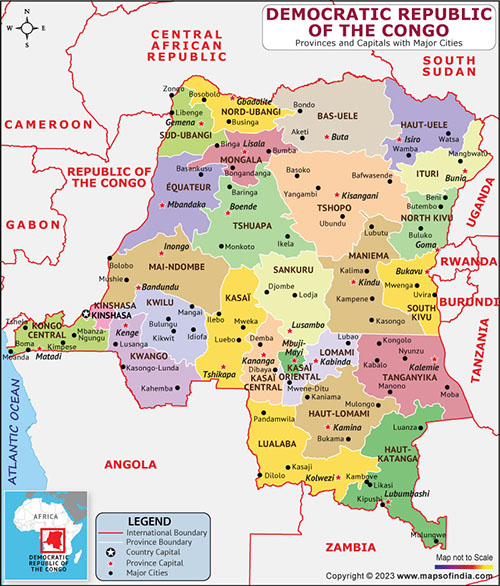 The second – largest country on the continent and the largest in East Africa with an area of (905,063 Sq. miles/2, 344,113 Sq. km), extending from the Atlantic Ocean east to Uganda, DRC is the Amazonia of Africa, but unlike the Amazon boasts no luxury cruises or comfortable eco – resorts. DRC’s borders enclose half of Africa’s rain forest, and tropical forest covers half the country. The rest consists of wooded and open savanna, as well as some montane habitats along the western rift valley in the far east. Rainfall is heavy in most areas, with high – sun rain in areas well to the north or south of the equator.
WESTERN DRC

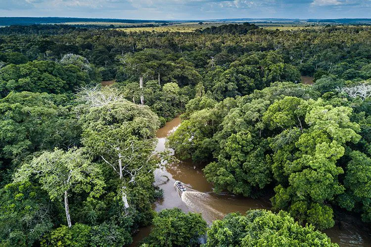
- Kinshasa, the capital, is located on the Congo River, south of Stanley Pool and northwest of Livingstone Falls. It receives 53” (1,325 mm) of annual rain, chiefly between October and May. Highs average 81- 90°F (27 - 32°C) year – round. There are no national parks nearby, but the Bombo – Lumene Game Reserve (592,800 acres/240,000 ha) to the east is a candidate. The mangrove - lined mouth of the Congo is in a moderate – rainfall area due to the effects of a cool, northward – flowing current offshore. The south bank of the river mouth is in Angola, while the north bank is in DRC. The interior of the broad and flat Congo Basin averages 1,000 -2000” (300 – 600 m) elevation; higher plateau country lies to the north and south. There are vast swamp and upland forests, with savannas where these have been logged. Salonga National Park (9,030,310 acres/3,656,000 ha), located in an area with no roads south of the town of Boende in west – central DRC, is accessible only by boat and has no lodging. It has elephants, buffalos, bongos, bushbucks, sitatungas, Congo peacocks, and long - snouted crocodiles. The park is home to many bush meat poachers and has virtually few visitors at this time. The forests between the Yekokora and Lomako rivers south of Lisala, in the northwest, shelter one of the closest animal relatives to humans, the bonobo (Pygmy chimpanzee), which has no reserve anywhere to protect it.
- THE NORTHEAST DRC
Kisangani is a major port on the Congo River just north of the equator. Maiko National Park (2,675,000 acres/1,083,000 ha) lies in rain forest along the Maiko River about 150 mi (244 km) southeast of Kisangani, but it lacks access and facilities. It was created for the Okapi and the Congo Peacock, and also has Grauer’s race of gorilla, the elephant, and the buffalo. The recently protected Okapi Wildlife Reserve is located at Epulu in the Ituri Forest, in the northeastern corner of the rain - forest zone. It is 264 mi (440 km) northeast of Kisangani on the road to the city of Bunia (west of Lake Albert). The tall forests here, which are home to Pygmy villages, have okapis, bongos, Bates’ pygmy antelopes (Dwarf Antelopes), elephant, chimpanzees, and the very local golden – napped and yellow – legged weavers. Garamba National Park/World Heritage Site (1,215,200 acres/492,000 ha) – is located in the northeast on the South Sudan border. While it has some evergreen forest and gallery forest, it is a savanna park, with tall grassland and papyrus swamps. It is on the Nile – Congo divide at elevations that reach 3,500” (1,060 m). This area is best visited between November and March, in the dry season. Valiant efforts are saving the last of the wild northern race of white rhinoceros. The rich mammal life here includes the chimpanzee, elephant, buffalo, giraffe, hippo, Derby eland, Jackson’s hartebeest, kob, waterbuck, and roan. Predators include the lion, leopard, wild dog, golden cat, serval, five mongooses, and two otters.
- THE DRC HIGHLANDS

DRC’s eastern border has a spectacular mix of rift valley lakes, high mountains, and a mosaic of wet forests and savannas. There are airports at the cities of Goma and Bukavu on Lake Kivu. Virunga National Park/World Heritage Site (1,951,300 acres/790,000 ha), one of Africa’s best reserves, is an enormous park with a diverse mix of landscapes and wildlife. Here are the highlights of northward from Lake Kivu to Mount Hoyo. Just north of Goma is the recently active 11,400” (3,475 m) Nyiragongo Volcano. Visitors to this area have many opportunities to see primates, including the Djomba and Rumangambo groups of mountain gorillas on the volcanoes, which can be seen on an organized tour, and chimpanzees at a chimpanzee sanctuary near a lodge at Tongo, west of the town of Rutshuru. Golden, spot – nosed, blue, and red and black – and – white colobus monkeys may also be spotted. The Rwindi and Vitshumbi sector of the park, on the southern side of Lake Edward, is in a rain shadow, accumulating only 20” (500 mm) annually. Its grasslands and lakeshores are home to abundant wildlife – elephants, buffalos, Kobs, topis, waterbucks, lions, and black – backed jackals. The lakeshore has many hippos, yellow – billed storks, hammerkops, and pelicans. The park also incorporates the western flank of the snow – capped Ruwenzori Mountains, which get 120” (3,000 mm) of yearly rain. Hikers need safari guides and must bring food to cook in primitive huts. The northern end of the park encompasses the slopes of Mount Hoyo, which are dotted with Pygmy villages. Among the area’s sights are its waterfalls and large forest hornbills. Kahuzi – Biega National Park/World Heritage Site (1,482,000 acres/600,000 ha), west of Goma, is home to eastern lowland gorillas, which are larger than mountain gorillas, with shorter hair and longer arms. Gorilla treks leave from Tshivanga, 20 mi (31 km) northwest of the town of Bukavu. This park has montane forest, bamboo thickets, and alpine heathland culminating on Mount Kahuzi at 10,853” (3,308 m). The western sector near Irangi (2,600”/800 m elevation) has lowland forest that gets 76” (1,900 mm) of annual rain, chiefly between September and May. Other wildlife includes the owl – faced monkey, both black – and - white and red colobus monkeys, duikers, chimpanzees, and forest birds, including the rare African green broadbill. The protected area of Itombwe Forest, west of the town of Uvira, is opposite Burundi, overlooking the northern end of Lake Tanganyika. There are also lowland and montane forests south of Uvira on Mount Nyombe and Mount Mohi, which reaches 11,400” (3,475 m). Gorillas and many endemic animals live in this isolated range.
- THE SOUTHEAST DRC
Lubumbashi, the chief city in the south, sits at an elevation of 4,035” (1,230 m) on a plateau of rolling grassland and wet miombo woodland. There is a long dry season between May and October; average highs reach only 79°F (26°C) in June at low sun. There are two national parks in the southeast where zebras, elands, roans, sables, leopards, and cheetahs live. Kundelungu National Park (1,877,200 acres/760, 000 ha) is 93 mi (150 km) north of – Lubumbashi at 3,900 – 5,600” (1,200 – 1,700 m) elevation. Its western border is a long escarpment of cliffs over which the Lofoi Falls drop 1,122” (342 m), one of the largest such drops in Africa. The park has the main DRC population of the greater Kudu, the Klipspringer, and the wattled crane. Upemba National Park (2,897,300 acres/1,173,000 ha), 250 mi (400 km) northwest of Lubumbashi on the eastern bank of the Congo River, encompasses lakes, marshes, and acacia Savanna flanked by plateau with miombo woodland. Formerly a black rhino stronghold, it is now home to elephants, hippos, buffalos, waterbucks, Lichtenstein’s hartebeests, lions, spotted hyenas, wild dogs, six primates, and two crocodiles. Robert’s lechwes live here and near Lake Mweru, east of Upemba on the Zambia border. Pukus roam the Luama Valley Reserve (839,800 acres/340,000 ha), northwest of the port of Kalemie on Lake Tanganyika.
- Background information; by edgardowelelo@yahoo.com
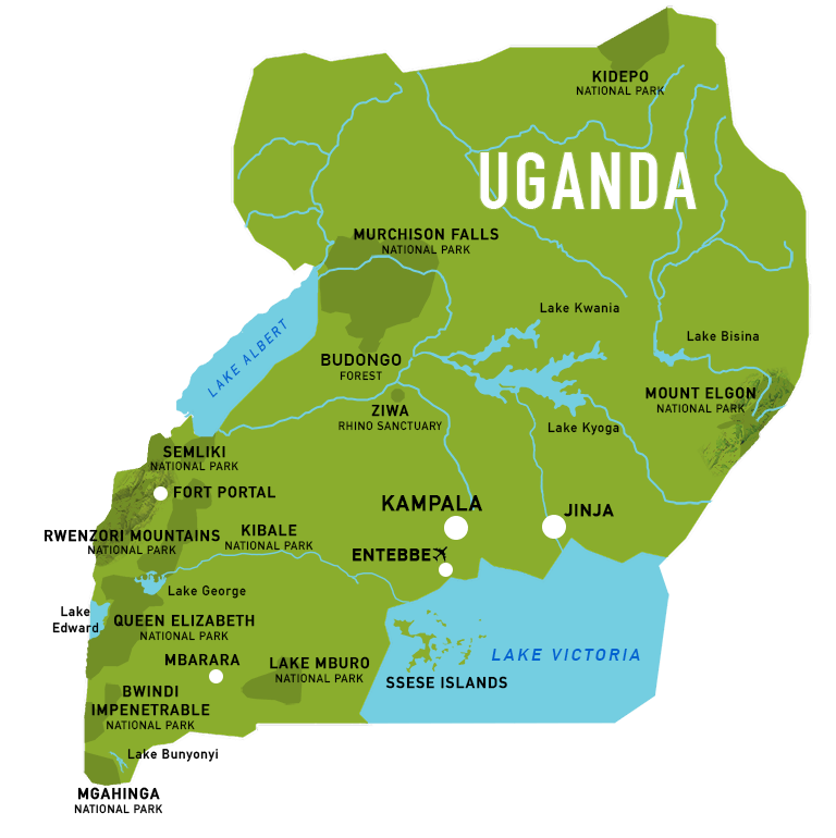 Uganda (91,134 Sq. miles/236,057 Sq. km) has a great mix of habitats among its many lakes and rivers. The Victoria (Nyanza) Nile flows out of Lake Victoria (Nyanza), first over a dam that has created Lake Kyoga, then over Murchison Falls; in the western rift valley it becomes the Albertine Nile. Uplifted and volcanic mountains line Uganda’s border with DRC. Much of the country lies on a plateau at 3,300 – 4600” (1,000 – 1400 m) elevation. It is mostly wooded savanna, but there are also papyrus swamps, montane forest, rain forest in the west, and semi – arid acacia savanna in the northeast. Despite the country’s position on the equator, the climate is pleasant.
- THE SOUTHEAST UGANDA
Entebbe is located at an elevation of 3, 878” (1,182 m) on the shores of Lake Victoria (Nyanza), just south of the capital, Kampala. Entebbe’s year – round rainfall of 60” (1,500 mm) peaks in April and May; its average highs range from 77 - 81°F (25 - 27°C). Entebbe Wildlife Education Center (12,646 acres/5,120 ha) has wild sitatungas, gray parrots, Ross’s turacos, and black – and – white Casqued hornbills in residence. North of Lake Victoria (Nyanza), Mount Elgon National Park, on an isolated Peak (shared with Kenya) that rises to 14,178” (4,321 m), protects montane forest and heathland.
- THE NORTHWEST UGANDA
 Murchison Falls (Kabalega) National Park (948,500 acres/384,000 ha), about 190 mi (304 km) northwest of Kampala, offers lodging, tracks, and boat trips along the Victoria Nile, which divides the park in two. The boats glide past hippos and crocodiles to the western base of the falls, which drop 130” (40 m). Most of the land is rolling grassland, with patches of forest at elevations of 1,650” (500 m) and higher. Among the mammals in residence are the elephant, buffalo, oribi, Jackson’s hartebeest, bohor reedbuck, waterbuck, lion, and leopard. The 350 species of birds include the rare shoebill and open - billed stork, African skimmer, red - throated bee – eater, and piapiac. The Budongo Forest, west of the town of Masindi, is an eastern remnant of the rain – forest zone of the Congo Basin. Despite heavy logging, it is home to chimpanzees and a rich array of birds.
- THE NORTHEAST UGANDA
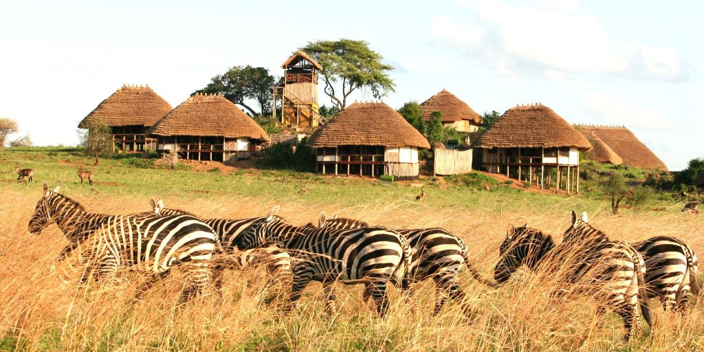
Kidepo Valley National Park (332,000 acres/134,400 ha) lies on the South Sudan border in Karamoja province. It has a lodge, and there is an airstrip at Apoka at 2,950’ (900 m) elevation. The best time to visit is between December and April. Unlike other Ugandan parks, Kidepo is chiefly sub desert, with seasonal rivers lined with borassus palms and some gallery forest. It is enclosed by wild mountains that rise up to 9,022” (2,750 m), with dry montane forest and grassland. It is the only Ugandan park with greater and lesser Kudus, the beisa oryx, Bright’s race of Grant’s gazelle, Chanler’s mountain reedbuck, Kirk’s dik – dik, bat – eared fox, cheetah, and ostrich. These are joined by – elephants, zebras, buffalos, roans, klipspringers, Rothschild’s giraffes, and Jackson’s hartebeests, as well as many birds; scissor – tailed kites, pygmy falcons, stone partridges, white – crested turacos, Abyssinian rollers, and Abyssinian ground – hornbills.
- SOUTHERN UGANDA
Lake Mburo National Park (132,400 acres/53,600 ha), located near the Tanzania border 120 mi (200 km) southwest of Kampala, has several bungalows for visitors. Open undulating grasslands, dotted with acacias, flank papyrus – bordered lakes. Among the park’s residents are Uganda’s only impalas, along with elands, roans, oribis, reedbucks, buffalos, zebras, spotted hyenas, and leopards. The 400 birds Include the rufous – bellied heron and southern red bishop. Kabale, 240 mi (400 km) southwest of Kampala, is the chief town of Kigezi province, in the southwestern mountains. Average highs are only 72 – 75°F (22 - 24°C); nights are cool. Mgahinga National Park (6,039 acres/2,445 ha), west of Kabale, protects montane forest and bamboo on the north slopes of peaks whose southern slopes are in Rwanda’s Volcanoes National Park. There are organized mountain gorilla treks here, and visitors may also see the golden monkey, Ruwenzori turaco, and regal sunbird. Bwindi Impenetrable National Park, which protects much of the Impenetrable Forest in western Kigezi, has both lowland and montane forest in a non-volcanic mountain range. Gorillas, chimpanzees, L’Hoest’s monkeys, and otter shrews are among the mammalian highlights here, while the rich forest avifauna includes great blue and black – billed turacos. Mountain gorilla treks depart from the town of Buhoma, which has a luxury tent camp and lodge nearby.
- WESTERN UGANDA
Ruwenzori Mountains National Park protects a spectacular range of non - volcanic mountains rising over the western rift valley. Called the mountains of the Moon, they are a jumble of glacier – flanked peaks, with Mount Stanley the highest at 16,763” (5,109 m). Guided treks, lasting five to seven days and using huts, leave from Ibanda, northwest of the town of Kasese. Primates and many unusual birds live in the montane forests and in the zone of giant lobelias, giant groundsels, moss, and tree ferns above the tree line. The weather is usually cloudy, misty, and rainy, with somewhat drier periods in January and February and between June and August. Queen Elizabeth National Park (488,600 acres / 197,800 ha) flanks both Lake George and Lake Edward,260 mi (420 km) west of the city of Kampala. The lodge at Mweya lies on a Peninsula in Lake Edward with spectacular views. Boat trips follow the Kazinga Channel between the two lakes past numerous hippos, pelicans, and Kingfishers (among 542 species of birds). Wildlife – viewing drives cross euphorbia - dotted grassland, acacia savanna, and swamps, and pass 80 volcanic craters. There are many elephants, Kobs, buffalos, and bushbucks, with fewer lions, leopards, and reedbucks. The lodge at Ishasha in the southern sector of the park is a good base for seeing topis and tree - climbing lions. Nearby Chambura Gorge has healthy populations of chimpanzees in the forest. Kibale National Park (189,200 acres/76,600 ha) claims the world’s highest density of primates and is one of Uganda’s most popular tourist draws. Located north of Queen Elizabeth National Park and south of the town of Fort Portal, it receives 60” (1,500 mm) of annual rain that supports dense forest, swamps, and grassland. Primates include bush babies, pottos, chimpanzees, gray – cheeked mangabeys, and red colobus, black – and - white colobus, blue monkey, LHoest’s, and red - tailed monkeys. The reserve is also home to the elephant, the golden cat, the serval, many duikers, and more than 300 bird species. Facilities for visitors have been developed at Kanyanchu on the park’s eastern border. Semliki National Park lies along the Semliki River, west of Fort Portal on the DRC border. Its fauna resembles that of the Congo Basin, with the black mangabey, De Brazza’s monkey, the giant forest squirrel, and 400 birds, including the white crested - hornbill and long – tailed hawk, in residence.
- Background information; by edgardowelelo@yahoo.com
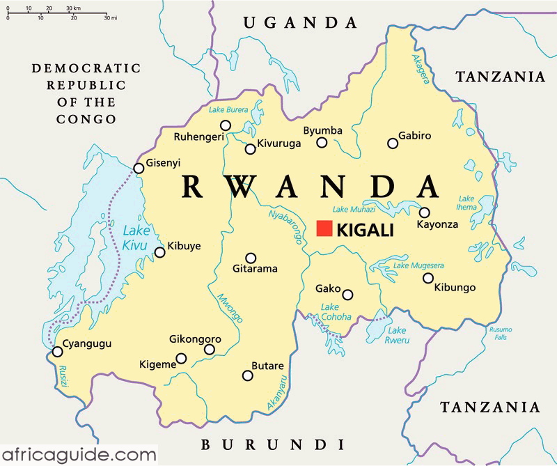 In the heart of central Africa, this small highland country (10,169 Sq. miles/26,338 Sq. km) is dramatically beautiful. Most of its rolling land, punctuated by terraced hills and mountains, stands above 5,000” (1,520 m). it is intensively cultivated, yet more than 10 percent of its land is protected. Kigali, the capital, which sits among farmed hills, receives about 50” (1,250 mm) of annual rainfall. Rwanda has four seasons; the long wet, from mid - March through mid – May; the long dry, through mid – September; the short wet, through mid – December; and the short dry, through mid – March.
- WESTERN RWANDA
The town of Ruhengeri, 60 mi (100 km) northwest of Kigali, has lodging for visitors setting out on gorilla treks in nearby Volcanoes National Park/Biosphere Reserve (37,100 acres/15,000 ha). The park protects the upper reaches (about 7, 900/2,400 m) of six dormant volcanoes rising in a row along the borders with DRC and Uganda. It abuts sister reserves in those countries. The park’s lower slopes – the gorilla’s primary habitat – are covered with dense montane forest and bamboo, while moorland with giant heath, lobelia, and groundsel prevails higher up. Frequently shrouded in clouds, the area has heavy rainfall (80”/2,000 mm annually), with some snow up high. Visitors can take hikes, ranging from four hours to two days, up several volcanoes.
Most visitors make a pilgrimage to visit with one of several groups of mountain gorillas that are habituated to humans. Limited to guided groups of eight, these require expensive permits. Hikes may involve scrambles up steep muddy slopes, often in the rain. Golden monkeys, yellow – backed duikers, and perhaps 200 species of birds (including the Ruwenzori turaco) also live here. Lake Kivu, a deep freshwater lake 56 mi (90 km) long, lies at the bottom of the western rift valley. The resort town of Gisenyi, at the northern end of the lake, is connected by road and ferry to Cyangugu at the southern end.

The Nyungwe National Park, 33 mi (54 km) east of Cyangugu on the main road east to the town of Butare, is a conservation area covering a large (239,600 acres/97,000 ha) forest tract on the Congo – Nile divide. Living among the forest’s enormous trees are 275 species of birds and 13 species of primates, including chimpanzees, black – and – white colobus monkeys, and L’Hoest’s, red – tailed, and golden monkeys. Views from the ridges to the lakes and volcanoes can be spectacular.
- EASTERN RWANDA
There are many water birds in the Mugesera – Rugwero lakes and swamps in the southeast, but no formal reserve exists to protect them. Akagera National Park (770,600 acres/312,000 ha) in the northeast is relatively low (4,265”/1,300 m) and dry, receiving 40” (1,000 mm) of rain annually. Most of the park is a mix of grassland and wooded hills punctuated with tall, cactus – like euphorbia trees. Akagera’s east side, bounded by the Kagera River, features vast swamplands, lakes, and islands, with sitatungas, hippos, shoebills, and crocodiles. The park’s mammal population includes the elephant, roan, eland, bushbuck, lion, leopard, and black rhino, along with herds of topis, buffalos, impalas, and zebras. More than 500 birds, 50 mammals, and 80 reptiles have been recorded. Civil war has taken a toll on lodges at lake Ihema in the park’s southern portion and at Gabiro in the north for the past years.
- Background information; by edgardowelelo@yahoo.com
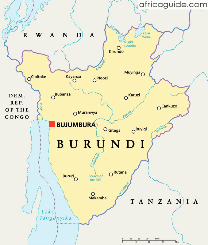 This small highland country (10,759 Sq. miles/27,866 Sq. km) on Lake Tanganyika encompasses part of the western rift valley, a mountain chain, and wooded savanna in the east. Annual rainfall is 33 “(825 mm) on the Lake, almost double that in the mountains. June through September are the drier months. Average highs are 82 - 88°F (28 - 31°C) on the lake, lower inland.
- WESTERN BURUNDI
The capital, Bujumbura, at the northern tip of Lake Tanganyika, at 2,525” (770 m) elevation, has boat connections to Kigoma Region, Tanzania. The lakeshore is lined with coconut palms and hippos. Tanganyika’s waters support 270 endemic fish, chiefly Cichlids, with an immense variety of color and behavioral characteristics. From the Bujumbura area there are fine views west to DRC’s Itombwe Mountains. Rusizi National Park (3,700 acres/1,500 ha) protects part of the Imbo Plain northwest of Bujumbura. The Rusizi Delta has marshes and lagoons that host saddle - billed storks and nesting skimmers. Another sector has dry palm forest and riverine habitats, with hippos, bushbucks, and Sitatungas. Elephants, common in the delta area before 1953, maybe introduced in the future.
- THE BURUNDI MOUNTAINS
A backbone of mountains that peak at 8,800” (2,680 m), the Congo – Nile Divide runs north – south. Lush montane forest, with vast areas of bamboo, is protected in Kibira National Park (93,540 acres/37,870 ha) in the north. Chimpanzees, gray – cheeked mangabeys, red – tailed monkeys, black – and – white colobus monkeys, duikers, and more than 150 birds live here. In the south only a fragment of montane forest remains, protected Bururi National Park (3,700 acres/ 1,500 ha).
- EASTERN BURUNDI

While rivers west of the mountains drop steeply, those in the east drop gradually in a northeasterly direction down to 5,000” (1,500 m). Ruvubu National Park (107,766 acres/43,630 ha) protects grassland and riverine forest along the Ruvubu River. Hippos, bushbucks, waterbucks, buffalos, lions, leopards, servals, spotted hyenas, and crocodiles live here. There is some miombo woodland, evergreen bushland, and acacia savanna in the southeast. The Lake Rwihinda Managed Nature Reserve (1,050 acres/425 ha) is located in the Busoni area of northeastern Burundi in an area of freshwater lakes with vast papyrus swamps and great nesting colonies of herons, ibises, and storks.
- Background information; by edgardowelelo@yahoo.com
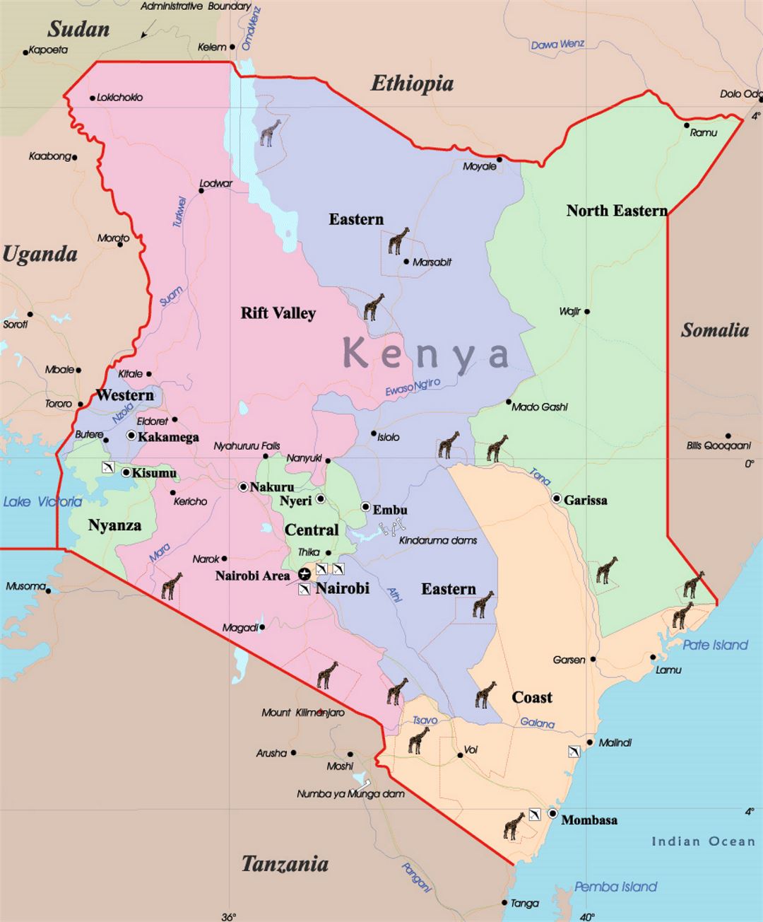 Encompassing 224,960 Sq. miles/582,646 Sq. km), Kenya straddles the equator between Lake Victoria (Nyanza) and the Indian Ocean. It harbors a rich diversity of habitats: grassy plains, rock – strewn deserts, fresh and saline lakes, forested mountains, palm – fringed beaches, and coral reefs. A green highland plateau, crowned by snow – capped Mount Kenya and cleaved by the arid eastern rift valley, covers much of the country. There are usually two rainy seasons, the long rains from March through May and the short rains in November and December. Temperatures in the highlands are pleasantly cool, despite their location on the equator. Kenya has done a remarkable job establishing wildlife sanctuaries. Its more than 18 national parks, 4 marine national parks, 4 marine reserves, over 23 national reserves, and 5 marine national reserves are the focus of the greatest wildlife tourism industry in the world.
- NAIROBI
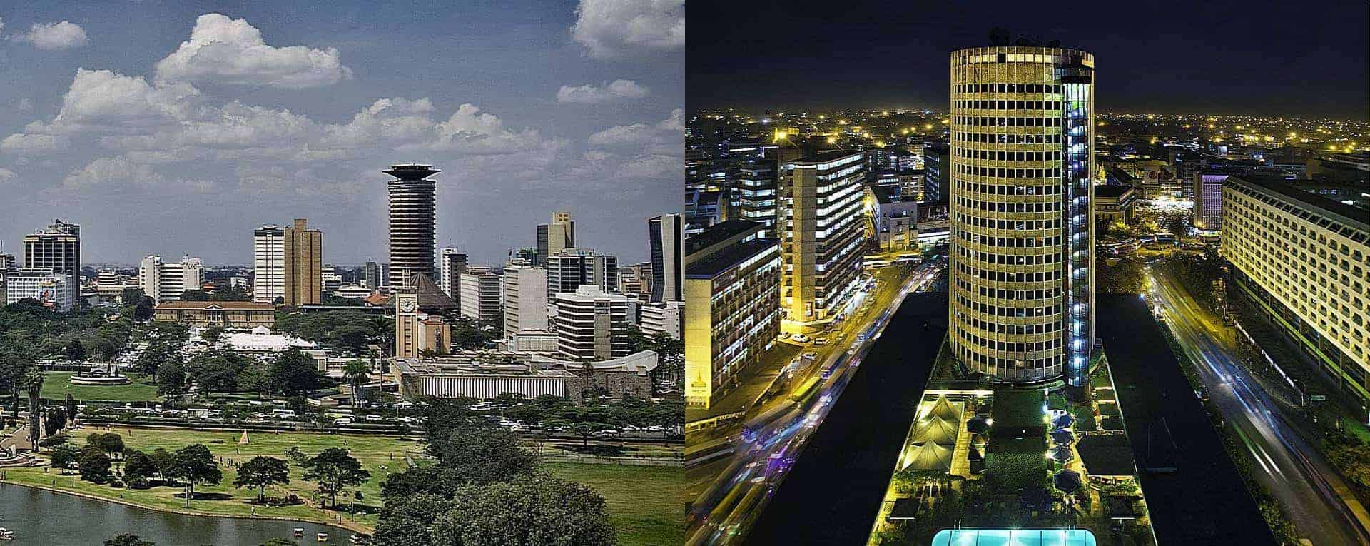 Nairobi, the capital, lies at the transition zone between the lower, drier plains to the south and east and the higher, greener highlands to the north and west. It receives 37” (925 mm) of rain annually. The average high is 70°F (21°C) in July, 79°F (26°C) in February. Nairobi National Park (28,951 acres/11,721 ha), just south of the city, has many waterholes and a network of tracks. Primarily rolling grassland, the park borders the forest – fringed Athi River, home to hippos and crocodiles. Heavily protected, black rhinos roam the park. Common grazers include zebras, giraffes, Thomson’s and Grant’s gazelles, hartebeests, wildebeests, bushbucks, elands, and ostriches. There are many lions, and fewer leopards and cheetahs.
- THE KENYAN HIGHLANDS
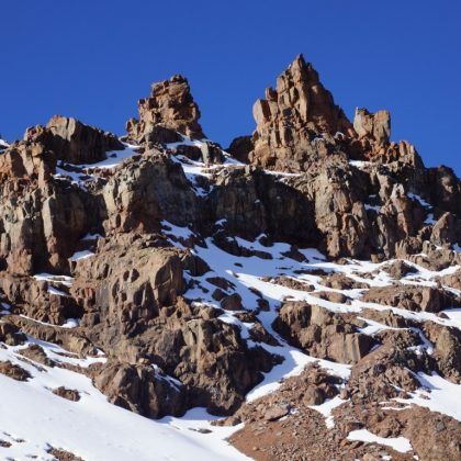 The central highlands lie to the north and west of Nairobi. Rainfall averages 50” (1,250 mm) a year and is much higher on some slopes. Often cold and drizzly between June and September, the area is sunniest from December through March. There are superb safari hotels between the Aberdare Mountains (Nyandarua) – west of the town of Nyeri and Mount Kenya (east of the town of Nanyuki). Nearby highland grasslands have long – tailed widow birds. Private ranches near Lewa Downs - and at Sweet waters, west of Nanyuki, offer camel and horseback safaris into animal – rich country. The region’s other facilities include a mountain lodge on the southwestern slope of Mount Kenya, and two (Treetops and the Ark) in the eastern Aberdares (Nyandarua). Each has a water hole and salt licks that attract elephants, buffalos, waterbucks, bushbucks, and sometimes bongos. Mount Kenya National Park (177,245 acres/71,759 ha) protects most of the land above 10,500” (3,200 m) on Africa’s second – tallest mountain (after Tanzania’s Mount Kilimanjaro). On clear days one can see the permanent snowfields on its twin glacial peaks, which reach 17,058” (5,199 m). There are lodges at the base of the Naro Moru trail on the west and the Simiron trail on the drier northwestern side. The trails pass by deep gorges and cut through dense montane forest hosting black – fronted duikers, sunis, blue monkeys, giant forest hogs, black – and – white colobus monkeys, and Hartlaub’s turacos. Above 11,000” (3,340 m) the forest yields to open moorland with giant heather and tall columns of lobelia and groundsel where the rock hyrax, several raptors, and the scarlet – tufted malachite sunbird are found. Aberdare National Park (Nyandarua) – 189,249 acres/76,619 ha) sits at the eastern edge of the rift valley. Soaring to 13,100” (4,000 m) elevation, it has heavy montane forest and moorland. Wildlife, difficult to see in such lush vegetation, is plentiful. There are more than 200 bird species, plus elephants, buffalos, bongos, lions, and black rhinos. Armed ranger guides are required when hiking.
- THE NORTH OF KENYA
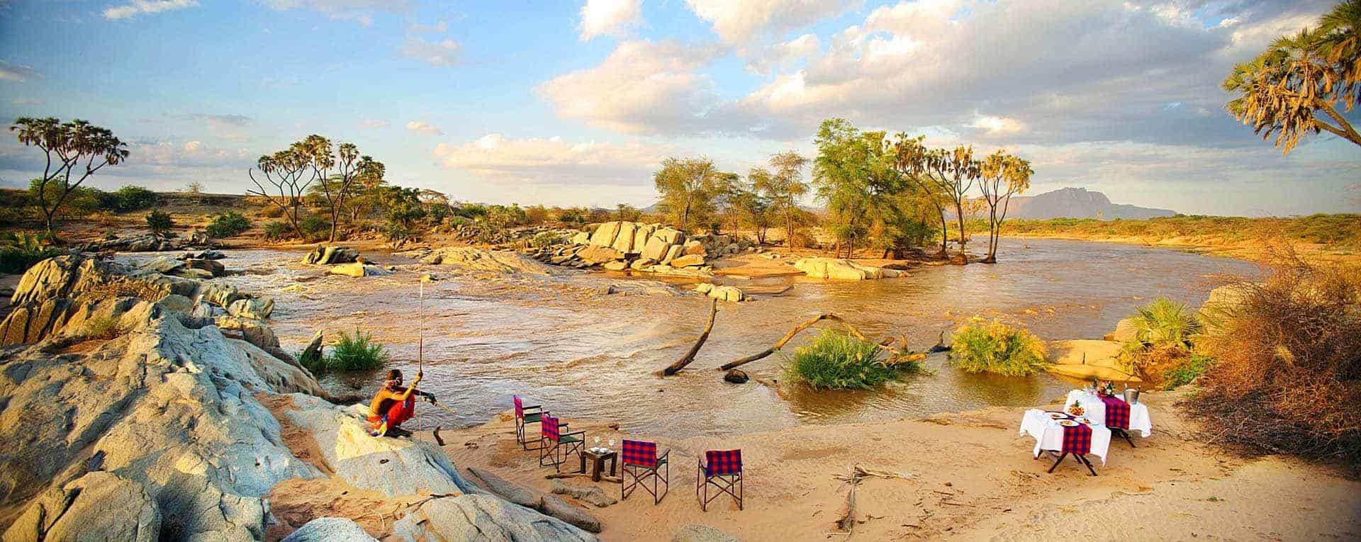
To the north of verdant Mount Kenya lies an austere semi – desert of thorn bush flats, dry grassland, open acacia woodland, and rugged ranges that averages only 14” (350 mm) of rain a year. These hot, sun – baked landscapes, home to red – robed goat and camel herders, extend north to Ethiopia and east to Somalia. At the southern edge of this arid region stands a trio of contiguous national reserves with varied lodging and good access by road from Nairobi, 200 mi (325 km) to the south. Samburu National Reserve 40,800 acres/16,500 ha), Shaba National Reserve (59,058 acres/23, 910 ha), and Buffalo Springs National Reserve (32,400 acres/13,100 ha) line the perennial Ewaso Ng’iro River, rimmed with towering river acacias and doum palms. The river and several springs attract much wildlife, especially in dry periods. Mammals restricted to the Somali – Maasai arid zone are found here, such as Grevy’s zebra, the reticulated giraffe (Somali giraffe), the beisa oryx, Guenther’s dik – dik, and the generuk. Also present are lesser Kudus, elephants, Grant’s gazelles, lions, cheetahs, leopards, and 350 bird species, including the blue – flashed Somali Ostrich, and the bristle – crowned starling. Meru National Park (214,999 acres/87,044 ha) lies southeast of Samburu and borders the Tana River, along with Kora National Park (441,587 acres/ 178,780 ha). Meru, well-watered by streams flowing eastward from the Nyambeni Hills and Mount Kenya, hosts many mammals: elephants, buffalo, plains zebras, Grant’s gazelles, leopards, servals, and hippos, plus arid – zone mammals, such as the beisa orxy, reticulated giraffe (Somali giraffe), and Guenther’s dik – dik. Birds include the vulturine guineafowl, golden pipit, and golden – breasted starling. North of Meru, in a scrubby and stony semi – desert, Marsabit Mountain rises to 5,594” (1,705 m). Protected in the little – visited Marsabit National Reserve (515, 700 acres/ 208,800 ha), this sky – high - oasis is pocked with volcanic craters, including Paradise Lake, with its lush montane forest necklace. Marsabit’s once abundant population of elephants, and its wildlife in general, has plummeted due to poaching and human encroachment. Still, more than 300 bird species and many mammals live here, including greater Kudus.
- KENYA’S RIFT VALLEY
 Kenya’s rift valley runs north – south and is generally hot and arid. It is bordered by tall cliffs in some areas and relatively shallow steps in others. Numerous lakes line the valley. Some are fresh and others alkaline, with salinity levels varying relative to rainfall. The most northerly, salty Lake Turkana, is the largest and lowest in elevation at 1,230” (375 m). Sabiloi National Park (388,000 acres/157,085 ha), on its eastern shore, embraces a petrified forest and abuts fossil beds that harbor early hominid remains. Thousands of crocodiles breed on Central Island, west of the park. In west – central Kenya, Lake Baringo, reached by paved road north of the town of Nakuru, is freshwater and has lodging and boat trips. Baringo is known for its density and variety of birds. Hundreds of species, including endemics, throng its shores and the surrounding woodlands and cliffs. Lake Bogoria National Reserve (26,441 acres/10,705 ha), east of the Baringo road, is a scenic soda lake with hot springs that erupt in boiling geysers. Its shores are often busy with flamingos. Lake Nakuru National Park (46,400 acres/18,800 ha) is a jewel in this chain of lakes, located south of the town of Nakuru on the main highway west from Nairobi. It is framed by tall cliffs and yellow fever trees, and encircled by a dirt track. The park is fenced to protect black and white rhinos that have been relocated here for sanctuary. Notable mammals include the Rothschild’s giraffe (Baringo giraffe/Ugandan giraffe), hippos, defassa waterbucks, bohor reedbucks, bushbucks, and leopards. Birds are the true highlight: Nakuru is “the most fabulous bird spectacle in the world” Most years its shores and shallow alkaline waters are jammed with birds: millions of lesser flamingos, thousands of greater flamingos, and vast numbers of pelicans, cormorants, herons, storks, ibises, ducks, geese, plovers, sandpipers, gulls, and terns. Nearby Lake Naivasha, a freshwater lake fringed with papyrus, supports fish - eagles, little grebes, red – knobbed coots, malachite kingfishers, and an array of other birds. Black – and – white colobus monkeys live in lakeside woods, while hippos graze ashore at night. Shoreside lodging and boating are offered. Hell’s Gate National Park (16,800 acres/6,800 ha), 8 mi (13 km) southeast of Naivasha, features a gorge with towering cliffs where Verreaux’s eagles and Ruppell’s griffon vultures nest.
- THE WEST OF KENYA
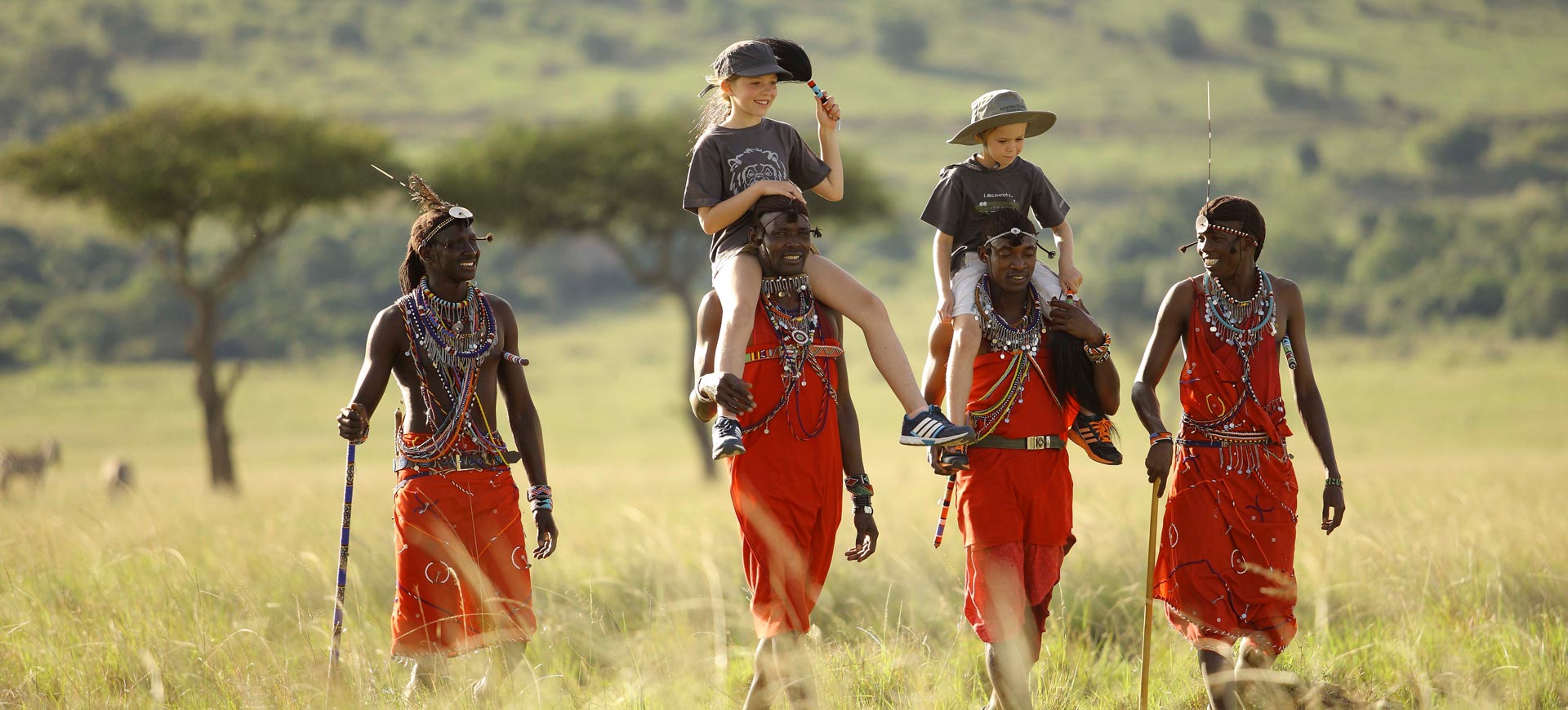
West of the rift valley Kenya is highly diverse, with hot semi – desert in the north, large areas of cool highlands, vast grasslands rich in game in the south, humid rain forest in the west, and papyrus beds on an inland sea. Maasai Mara National Reserve (373,000 acres/151,000 ha) is the northern extension of Tanzania’s famous Serengeti Plains and is usually called “the Mara”. Reachable by road or air from Nairobi, the Mara is Kenya’s premier place for seeing wildlife. It features many excellent game lodges and camps, and a wide network of dirt roads slice through its open rolling grassland and wooded savanna. Two sizable rivers, the Mara and Talek, wind through the landscape, flanked by gallery forests and seasonal marshes. The reserve is most extraordinary between July and October, when well over 2 million migrant herbivores (especially wildebeests and zebras) settle in for dry – season grazing. Besides migrants, the Mara hosts resident populations of elephants, hippos, topis, hartebeests, buffalos, giraffes, Thomson’s and Grant’s gazelles, impalas, Kirk’s dik – diks, and a few black rhinos. Predators are plentiful, notably cheetahs, leopards, and unusually large prides of lions. Birding is excellent around the lodges and from vehicles; 450 species have been recorded, including 54 raptors (Birds of prey). The gallery forests host primates and a number of birds usually found further west. The pastoral Maasai people lead a semi – nomadic life just outside the reserve. Northward, Kisumu is the main Kenyan port on Lake Victoria (Nyanza). With an elevation of 3,725’ (1,135 m), Kisumu has rain all year, with the annual accumulation of 45” (1,125 mm) mainly concentrated between March and May. Average highs are 81 - 84°F (27 - 29°C). The lake, not part of either the eastern or the western rift valley, is banked with papyrus beds that attract many water birds and a number of songbirds not found elsewhere in Kenya. Kakamega Forest National Park (11, 036 acres/4,468 ha) is located east of the town of Kaka mega, 32mi (51 km) north of Kisumu. It is a relict of a much larger tract of wet tropical forest that once covered the area. some of its wildlife and many of its 125 species of trees are those of the Congo Basin and are not found farther east. Kenya’s only true “jungle’”, this area is overlooked by most tourists. Mammals of note include the red – tailed monkey, blue monkey, and duikers by day, and the potto, tree pangolin, and giant flying squirrel at night. Highlights among the 320 bird species are the gray parrot, great blue turaco, Narina’s trogon, black – and - white Casqued hornbill, African broadbill, and many barbets, wattle – eyes, sunbirds, and weavers. There are fine walking trails and a rest camp. Mount Elgon National Park (41,800 acres/16,923 ha) covers a flank of this 14,178” (4,321 m) peak on the Uganda border north west of the town of Kitale. It has a lodge and features a cave that elephants enter for mineral salts, plus trails through montane forest and moorlands dotted with giant groundsels and lobelias. Tiny Saiwa Swamp National Park (470 acres/190 ha) is located 11 mi (18 km) southeast of Kitale. Sitatungas inhabit its marshes, while De Brazza’s monkeys and Ross’s turacos live in nearby woodland. Descending the highlands north over the Kongolai Escarpment takes one into dry woodland, home to the stone partridge, the yellow – billed shrike, and the curly - crested race of the white helmet – shrike.
- THE SOUTHEAST KENYA

Between Nairobi and the Kenya coast sprawl three superb national parks. Maasai herders inhabit nearby grasslands studded with baobab trees and open acacia woodland. Amboseli National Park (96,838 acres/39, 206 ha), reached via air or road 150 mi (240 km) south of Nairobi, is Kenya’s most visited game park, offering fine lodging, abundant mammal and bird life, and the dramatic backdrop of snow – capped Mount Kilimanjaro, just across the Tanzania border. Its Saline lake is usually dry, but the park embraces two large, spring – fed swamps that provide permanent water to a region that receives only 12” (300 mm) of rain a year. This is a splendid place to view elephants. Some 55 other mammal species roam the land, including lions, leopards, cheetahs, impalas, Grant’s gazelles, elands, fringe – eared oryxes, gerenuks, buffalos, and a few black rhinos. Many wildebeests, zebras, and Thomson’s gazelles leave the park during the rains but return to be near the swamps in the dry months. More than 425 species of birds live here, with the Taveta golden weaver a highlight, and ostriches, vultures, eagles, bustards, sandgrouse, hornbills, and larks common in the grasslands. Tsavo East National Park (2,901,500 acres/1,174,700 ha) and Tsavo West National Park (2,239,100 acres/906,500 ha) flank both the highway and the railroad that link Nairobi to coastal Mombasa (roughly 200 mi / 335 km southeast). There are excellent lodges, most with water holes to attract animals, and some (in Tsavo West) with views of Kilimanjaro. The Galana River, with its attendant gallery forests and seasonal swamps, snakes through both parks. Enormous baobabs provide nesting sites for many parrots, rollers, and barbets. Giraffes, buffalos, elands, gazelles, waterbucks, gerenuks, lesser Kudus, and elephants browse the bushed terrain; lions are numerous. Tsavo West has recent volcanic craters and lava flows, as well as Mzima Springs, a lush oasis where hippos breed. More than 400 species of birds have been recorded, including Eurasian migrants and relatively local “east of the rift” species such as the vulturine guineafowl, golden pipit, and Fischer’s and golden - breasted starlings. Freshwater Lake Jipe, on the Tanzania border, draws many water birds, including the black heron.
- THE KENYA COAST
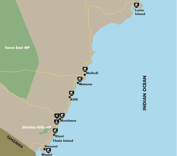 At Mombasa, Kenya’s chief port, the airport serves direct flights to and from Europe and Nairobi. The city gets 47” (1,175 mm) of rain, spread throughout the year with a peak between April and June. Average highs are 81 - 88°F (27 - 31°C). Kenya’s 300 – mi (480 – km) shoreline on the Indian Ocean is endowed with sublime white sand beaches and a colorful chain of fringing coral. On shore breezes temper the heat and humidity. Portions of the shore and coastal waters are protected as marine national parks and reserves, most with fine accommodations nearby, including Kiunga (in the north), Ras Tenewi, Malindi / Watamu, Mombasa, and Kisite / Mpunguti (in the south). Carmine bee – eaters roost on mangrove islands above the town of Kilifi, while crabplovers and myriad waders throng the flats of Mida Creek in Watamu reserve. Inland, Shimba Hills National Reserve (47,550 acres/19,251 ha), 35 mi (56 km) southwest of Mombasa, is home to sable and roan antelopes. Coastal woodlands such as Shimba Hills host birds not found elsewhere in Kenya, including Fischer’s turaco. Many very rare birds and the yellow – rumped elephant – shrew live in the dense woodlands of Arabuko Sokoke Nature Reserve (10,700 acres/4,332 ha), between Kilifi and Watamu. Tana River Primate Reserve (41,700 acres/16,900 ha), which lies 74 mi (120 km) north of Malindi, protects the Tana crested mangabey and red colobus. The very local Hunter’s antelope (Hirola) lives in Arawale National Reserve (131,710 acres/53,324 ha), 25 mi (40 km) farther north.
- Background information: by edgardowelelo@yahoo.com
 On 24th November 2023, Somalia was officially admitted as the eighth (8th) member to the East African Community (EAC), nearing to a successful climax an aspiration that began more than a decade ago. The membership will become official once Somalia’s Federal Parliament ratifies the Treaty of Accession. Somalia is known for its long coastline, beaches, waterfalls, mountain ranges, national parks, and a long list of numerous historical sites drawing both foreign and domestic tourists. Somalia is home to several species of wildlife and vast wilderness and mountains.
- NATIONAL PARKS AND WILDLIFE RESERVES
These include Daalo Mountain National Park (Sanaag Region), Hargeisa National Park (Wogooyi Galbeed Region), Hobyo National Park (Mudug Region), Jilib National Park (Middle Juba Region), Kismayo National Park (Lower Juba Region), and Lag Badana National Park (Lower Juba Region).
- WILDLIFE RESERVES
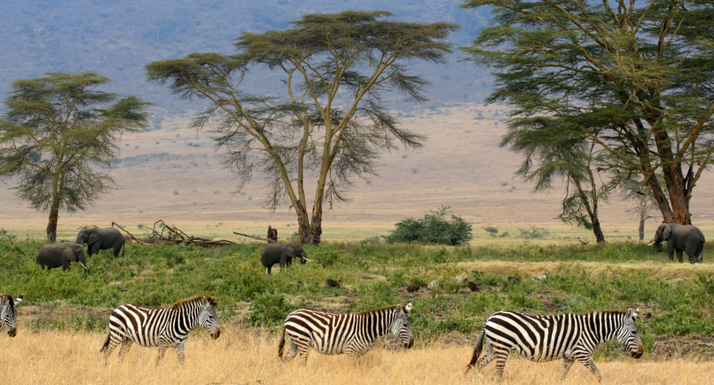
These include Awdhegle – G wildlife Reserve, Boja Swamps Wildlife Reserve, Dandoole Wildlife Reserve, Haradere Wildlife Reserve, Jowhar Wildlife Reserve, Lag Badane Wildlife Reserve, and Lack Dare Wildlife Reserve.
- WHY SOMALIA?
Somalia is located strategically in the Horn of Africa, bordered by Ethiopia in the west , Djibouti to the northwest, the Gulf of Aden to the north, the Indian Ocean to the east, and Kenya to the Southwest. Somalia has the longest coastline in the world and a total country surface area of 637,657 Km2. .The country has four (4) deep water ports located in the economic centers of Mogadishu, Berbera, Kismayu and Bosaso. Bosaso’s port is the main seaport for Puntland and Somalia’s central region. A major export passing through the port is live animals. Hobyo port is a small harbor at present with plan to expand for fisheries and export / import use. Mogadishu port is classified as a major port, and it has the largest harbor in the country. Major agricultural exports through the port include sesame, lemons and bananas. A special economic zone (SEZ) is planned. Caracaad port is recently constructed first phase of deep water port intended to serve local and eventually to Ethiopia. Merca port is a small harbor built for the export of horticultural produce (mostly bananas). Kismayo port is Somalia’s third – largest port. A major export passing through the port is live animals, and an SEZ is planned. And finally Berbera port.
- SOMALIA AT A GLANCE
Somalia, which occupies most of the Horn of Africa, is the centerpiece of a vast area of arid country, known as the SOMALIA – MAASAI ARID ZONE, that stretches from southern Eritrea south to northeastern Tanzania. As one of the few dry areas on the equator, most of the country gets less than 10” (250 mm) of rain annually, and vast areas are desert scrub. Somalia has perhaps the least spoiled coastline in Africa, hosting major nesting colonies of Crab plovers. The country’s total area is 246,154 square miles (637,539 Sq. km2).
- THE SOUTH

Mogadishu, the capital, gets 18” (450 mm) of rain yearly, chiefly between April and November. The Scebeli River, which runs parallel to the coast inland from Mogadishu, is one of two rivers that enter Somalia from the Ethiopian highlands. Balcad Nature Reserve (470 acres / 190 ha) protects an area of riverine forest and grassland 19 mi (30 km) north of the city. More than 200 birds occur, including the goliath heron, carmine bee – eater, golden weaver, and sulphur – breasted bush – shrike. Alifuuto Nature Reserve (444,600 acres / 180,000 ha) is a swampy area along the river 110 mi (170 km) north of Mogadishu that has been home to the elephant, giraffe, hippo, buffalo, many antelopes, and the Ostrich. The Juba River, further south, has also had much wildlife in the past. Bush – Bush Lake Badana Game Reserve (825,000 acres / 334,000 ha), in the far south, has a mix of habitats, including woodland, acacia savanna, seasonal lakes, and coastline. Native mammals here include the elephant, buffalo, lesser Kudu, beisa oryx , reticulated / Somali giraffe, Peter’s race of Grant’s gazelle, Hunter’s hartebeest, lion, cheetah and leopard. Offshore, the Badjouini (Bajuni) Archipelago stretches from the city of Kismayu south to Kenya. The coral reefs idyllic islands here support a rich variety of marine life, including dugongs.
- THE NORTH
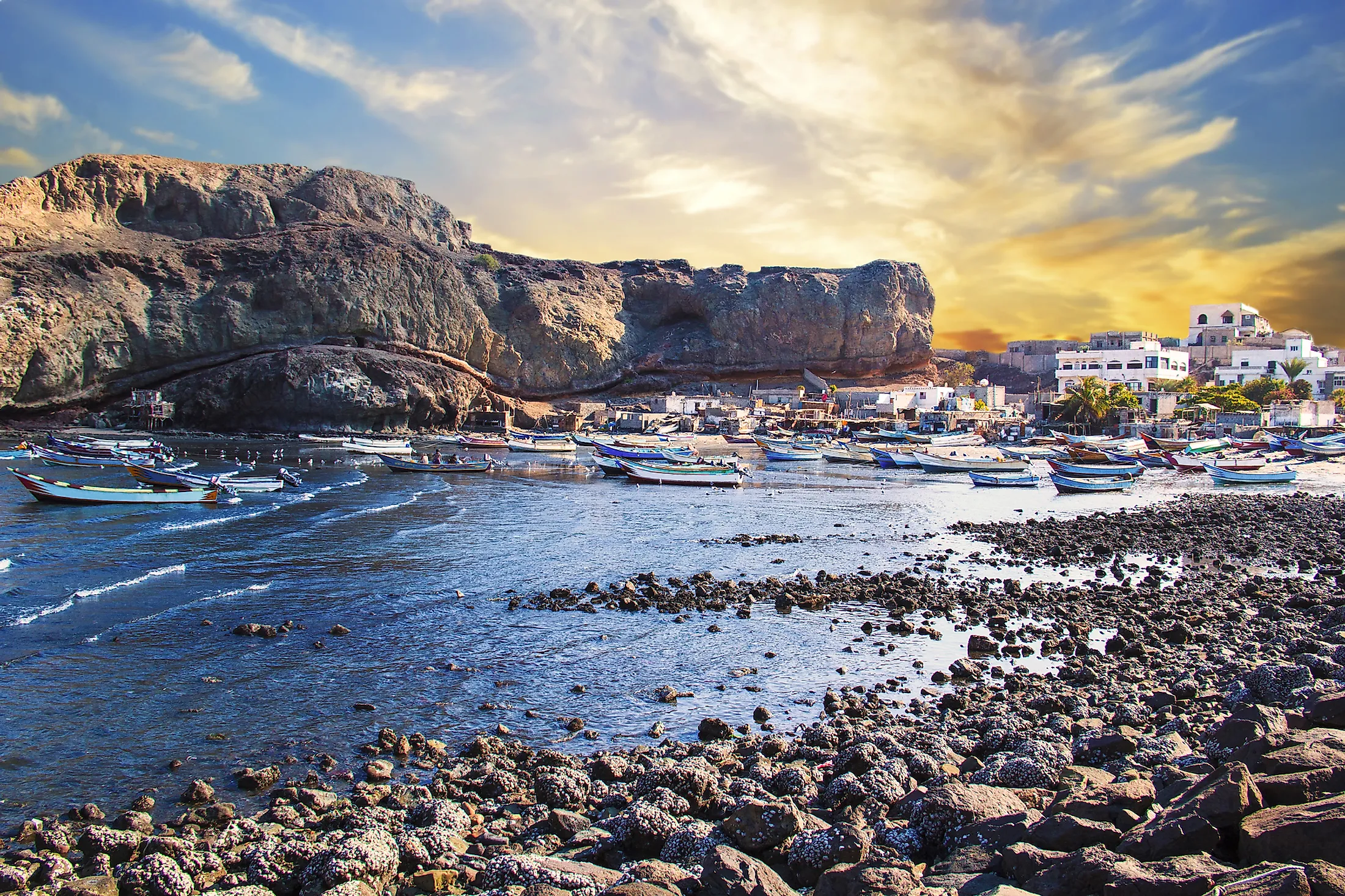
The Gulf of Aden coast is cooled by cold offshore currents in winter. Berbera, the main port city, gets 2” (50 mm) of rain in its relatively cool winter, when highs average 106ᵒF (41ᵒC). Pelzeln’s gazelles live on the coastal lowlands along the gulf. The Yemeni Islands of Kuri and Socotra, off the tip of the Horn, are rich in endemic species. Inland, a great range of mountains with peaks exceeding 7,000” (2,100 m) runs east – west. The mountains, which receive more rain than lowland areas, have bushland and remnants of juniper forest: several proposed parks have endemic birds. To the south of the mountains, the stark landscape of the low plateau drained by the Nogal River is home to the wild ass and a number of rare antelopes, such as speke’s gazelle, the dibatag, and the beira.